Preview image. Unlock full-res
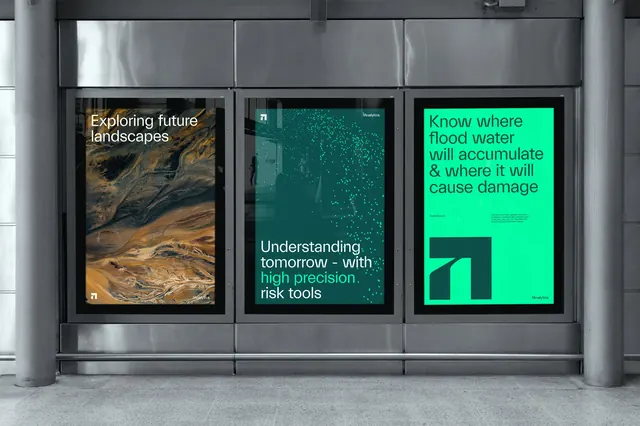
Three lightbox posters in a station interior running an aerial river-delta photograph, a dark teal panel with a scatter of green data dots, and a bright green panel dominated by the angular 7Analytics mark.
More like this
See all

Summary
A three-poster run that steps from photography to data pattern to pure mark, held together by one green and one dark teal and a single left-aligned sans-serif.
Visual description
Three portrait posters sit in dark frames inside a brushed-steel display case against a grey interior. The left poster is a full-bleed aerial photograph of a braided river delta in rust, ochre and near-black, with "Exploring future landscapes" in white sans-serif top left and the small angular mark bottom left opposite a "7Analytics" wordmark. The centre poster is dark teal with a diagonal drift of small bright green dots falling from the top right corner toward the lower right, thinning as it goes; "Understanding tomorrow - with high precision risk tools" sits bottom left in white with the middle phrase picked out in the same green. The right poster is flooded in bright green with dark teal type: a four-line headline "Know where flood water will accumulate & where it will cause damage", a url and a short paragraph of body copy in a two-column band below it, and the logo mark reproduced very large in the lower left as a solid dark shape.
Key takeaway
Reserving one poster in the run for the mark at maximum size, with no image and almost no copy, buys the identity recall the other two cannot. The dot scatter is a cheap, ownable way to draw rainfall or data density without a chart.
Reuse notes
Well suited to climate, risk and analytics brands that need to look both scientific and legible in public space. The system depends on a strict two-tone palette, so the aerial photography must be colour-selected to sit against green and teal rather than dropped in freely.