Preview image. Unlock full-res
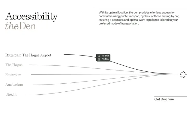
Minimal accessibility section with converging route lines from Dutch cities to theDen and a travel-time tooltip.
Summary
Editorial accessibility block mapping commute times from regional hubs to theDen via converging curved lines and a tooltip.
Visual description
Off-white background with thin horizontal rules. Left shows large serif "Accessibility" with italic grey "theDen" sub-brand. Right paragraph about public transport, cycling, and car access. Center-bottom infographic lists Rotterdam The Hague Airport, The Hague, Rotterdam, Amsterdam, and Utrecht with thin black curves meeting a diamond-ring destination icon. Dark grey tooltip on airport line shows 15 min by car and 59 min by transit icons. Bottom-right underlined "Get Brochure" link with extending rule.
Key takeaway
Route lines converging on one icon communicate location advantage without a literal map embed. Tooltip on one line samples data without cluttering every route.
Reuse notes
Commercial real estate or campus sites near transit hubs. Needs accurate travel data; serif editorial tone suits premium office brands.