Preview image. Unlock full-res
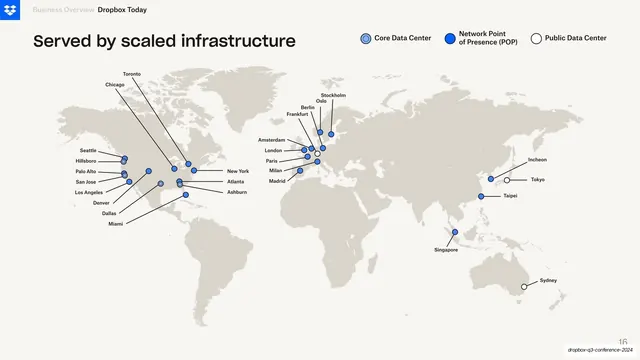
Cream slide with a flat world map plotting Dropbox data center and POP locations as labeled blue dots.
Summary
An infrastructure-footprint slide: a flat grey world map on cream, dotted with Dropbox data center and network locations, each pulled out to a city label by a thin leader line.
Visual description
Warm off-white background. A bold near-black headline, "Served by scaled infrastructure", sits top-left, with a three-item legend top-right distinguishing Core Data Center (ringed dot), Network Point of Presence / POP (solid blue dot), and Public Data Center (open circle). The body is a single flat light-grey landmass map with no country borders. Locations are marked by small dots in the three legend styles, clustered on the US coasts, Europe, and East Asia, each connected by a hairline leader line to a small city name (Seattle, New York, London, Frankfurt, Tokyo, Singapore, Sydney, and more). Dropbox blue is the only accent color; everything else is monochrome grey on cream.
Key takeaway
Encoding three node types in one map through dot style alone (ringed, filled, hollow) and explaining them with a compact inline legend, so a dense footprint reads at a glance. Leader lines let you label tight clusters without overlapping the dots.
Reuse notes
A clean template for any "global scale" or coverage slide: infrastructure, office locations, customer presence. Works best when the map stays borderless and grey so the colored nodes carry all the attention. Gets crowded fast in dense regions, so reserve the leader-line treatment for that.
From this deck: Global infrastructure world map
View deck
















More like this



Keep what you find
A free account saves references to boards and can send you a weekly email of picks based on what you save.
To see every result, go Pro.